In an era where data is the new gold, geospatial data emerges as a crucial asset for businesses aiming to navigate the competitive landscape with precision and insight. YelloSKYE Maps stands at the forefront of this revolution, offering advanced geospatial data solutions that transform how businesses plan, decide, and grow. This blog delves into the transformative power of geospatial data and how YelloSKYE Maps is unlocking new horizons for businesses across the globe.
The Power of Geospatial Data in Modern Business
Geospatial data, or geographic information, pertains to data linked to a particular spot on the Earth’s surface. This data, sourced from satellites, aerial photography, and, increasingly, UAV or drone technology, holds the key to unlocking myriad insights about land use, environmental changes, urban planning, and more. For businesses, geospatial data is not just about maps and satellite images; it’s a strategic tool that enhances decision-making, optimizes operations, and carves out a competitive edge in the market.
Drone Mapping Solutions: A Gateway to Advanced Geospatial Insights
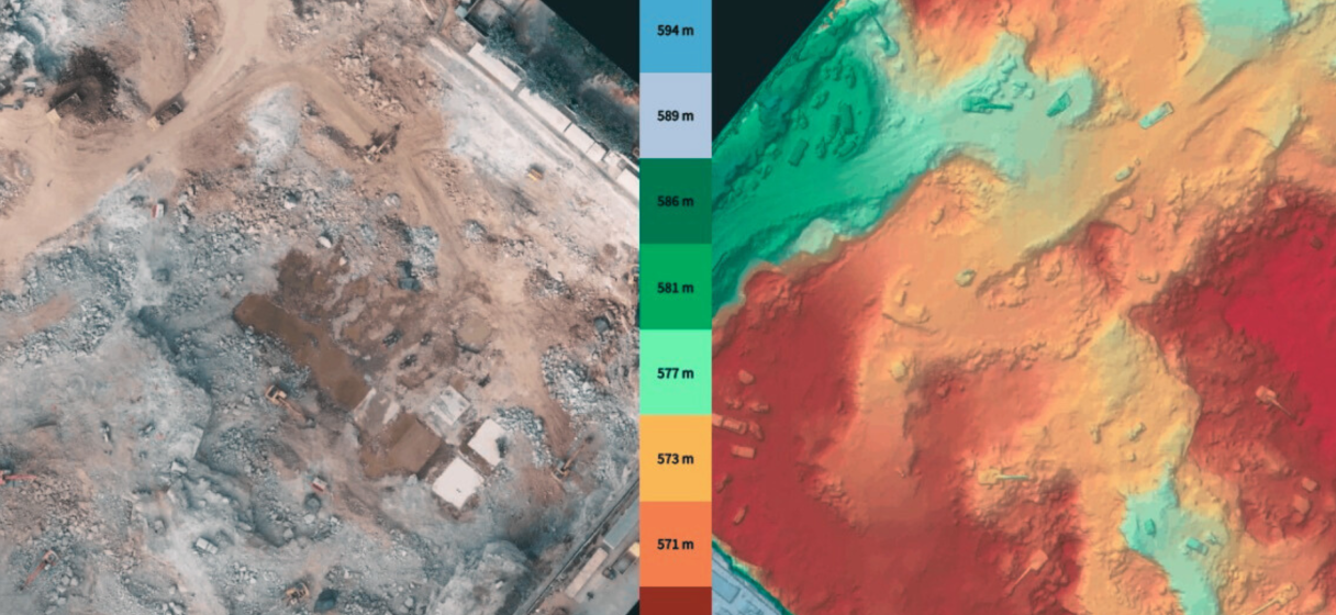
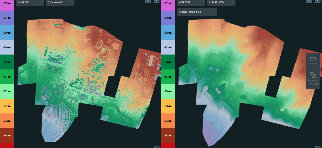
Advanced Mapping Solutions brings the world to your desktop with its cutting-edge platform, offering a suite of geospatial data services that cater to a broad spectrum of business needs. From Digital Surface Models (DSM) that provide a top-layer view of the Earth’s surface, including vegetation and man-made objects, to Digital Terrain Models (DTM) that reveal the bare ground surface devoid of any objects, Drone Mapping Solutions offer unparalleled precision and detail. The platform also provides Orthomosaic Maps, which are large, map-quality images made by combining aerial or satellite photographs, offering businesses a bird’s-eye view of vast areas with stunning clarity and detail.
Real-World Applications and Success Stories
The applications of geospatial data span across industries, reshaping how businesses approach challenges and uncover opportunities. In construction and real estate, Drone Mapping Solutions aids in site selection, planning, and monitoring, offering a detailed view of the terrain and surrounding infrastructure. For the agriculture sector, it enables precision farming practices by providing insights into crop health, soil conditions, and water usage. Environmental monitoring, disaster management, and urban planning are other areas where Advanced Mapping Solutions’ geospatial data plays a pivotal role, helping organizations make informed decisions based on accurate, up-to-date geographic information.
Success stories abound where Advanced Mapping Solutions has empowered businesses to achieve remarkable outcomes. For instance, a real estate developer utilized the platform’s detailed terrain models and Orthomosaic Maps for a large-scale development project, resulting in optimized land use, efficient planning, and significant cost savings. Another example is a utility company that leveraged Drone Mapping Solutions to monitor and maintain its extensive network, enhance operational efficiency, and reduce the risk of outages.
Navigating the Future with Advanced Mapping Solutions
As we look to the future, the significance of geospatial data in driving business and societal progress cannot be overstated. Advanced Mapping Solutions is at the cusp of this evolution, continually enhancing its platform to meet the growing demands of urban development, smart cities, and sustainable management of natural resources. With the emergence of AI and machine learning technologies, the potential to extract even deeper insights from geospatial data is boundless, promising a future where decisions are more informed, strategies more robust, and businesses more resilient.
Getting Started with YelloSKYE Maps
Embracing geospatial data with Advanced Mapping Solutions is a straightforward journey towards unlocking your business’s full potential. With a user-friendly platform and a dedicated team of specialists ready to assist you, Advanced Mapping Solutions ensures that integrating geospatial insights into your business operations is seamless and impactful. Whether you are looking to optimize your current operations or explore new opportunities, Advanced Mapping Solutions offers the tools, support, and expertise to guide you every step of the way.
Conclusion
The sky truly is the limit when it comes to harnessing the power of geospatial data with YelloSKYE Maps. The insights offered by advanced geospatial data solutions become indispensable in the ever-evolving and intricate landscape of a dynamic world. YelloSKYE Maps stands ready to be your partner in this journey, offering a window to a world rich with possibilities and ripe for exploration.
Don’t let traditional limitations ground your business. Reach for the sky with YelloSKYE Maps and unlock a world of business potential with the power of geospatial data.